
When using maritime transport, many importers encountered the problem of deliveries’ delays. In case of such a problem, specific web portals are allow us to check the location of the ship transporting our cargo. With their help we can find out where the selected vessel got stuck on its route and how long its delay is. How to check ships’ locations?
AIS – Automatic Identification System
Acquisition of data enabling the ships’ localization is possible mainly thanks to the AIS (Automatic Identification System). It also allows the exchange of helpful information that prevents collusions. In addition to the vessels’ locations, it provides statistics, course and speed data, the destination port, and the estimated time of arrival. One of the web portals acquiring and presenting data from the AIS system is Vessel Finder.
How to use web portals sharing ships’ locations?
Nowadays, we can find many sources on the Internet that provide information about the localization of vessels. We can check selected unit’s location, for example, using the previously mentioned Vessel Finder. Although the website may seem complicated at first, in reality, it only takes as much as a few clicks to check where our cargo is stuck and when we can expect its delivery. To simplify the search, the portal allows us to change the language in the upper right corner. Vessel Finder is available in twelve languages: English, German, Danish, Dutch, Spanish, Polish, Bulgarian, Turkish, Russian, Italian and Greek.

How to check the details of any vessel?
Right after loading the page, we gain access to the interactive map, where we can see the currently sailing ships’ locations. If we place the mouse pointer on one of the points on the map, we will see its name and when the data about its localization was acquired. However, if we click on the selected unit, an additional window will open on the website’s left side, containing more details about it. Here, we will also check the type of the ship, its current speed, course, draft, and other data. We can even find out what weather conditions are like at the place of its location.

The interactive map provides the website’s users with some additional useful functions. For example, they can mark and check the distance between selected points using the compass symbol. Furthermore, it’s also possible to change the type of map to show the current wind speed, temperature or waves.
How to check the details of the selected vessel?
In order to check the specific ship’s current location, enter its name in the top right corner of the page. Then select the vessel you’re interested in from the list displayed below.
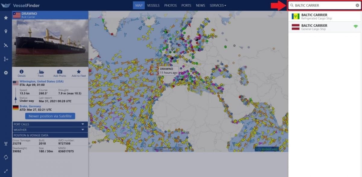
In this way, the website will redirect us to a page where we can find all the detailed data about the searched ship. As shown in the image below, the information obtained through the AIS system is gathered under the vessel’s photo, that is:
- Type of the ship;
- Flag;
- Next destination;
- ETA – estimated time of arrival to the port;
- IMO and MMSI numbers;
- Callsign;
- Length/Beam;
- Current draught;
- Course and speed;
- Coordinates;
- Current status;
- Time of acquiring information about its location.
What’s more, we can also see the vessel’s localization on the mini-map and current weather conditions on the right side. To check the position of the unit on the general world map, select the “Track on Map” option located just below its photograph.

Other web portals
We can also check the localization of the selected ship via the My Ship Tracking website. It is not available in as many languages, however its transparency makes it equally easy to use. In addition, My Ship Tracking has a phone application for both Android and iOS.
Using the web portal is similar to using the Vessel Finder. In this case, after opening the site, we will also see the world map with marked locations of the currently sailing vessels. On My Ship Tracking, we can filter the displayed ships according to, e.g., their type or size. Filtering options can be found on the left side of the map, wherein the “Layers” tab we can check its legend as well.
As when using the previous website, we can also search for any ship by entering its name in the upper right corner of the page. My Ship Tracking will show us its localization by zooming in on the map and displaying an additional window with more detailed information about it. It presents data such as:
- Name and photo of the vessel;
- Speed;
- Course;
- Time of acquiring information about its location;
- Port of departure;
- Destination;
- ETA – estimated time of arrival to the port;
- Total travel time;
- Current draught;
- Type of the ship and its measurements;
- Current status.
The attached image shows the data mentioned above for HMM SOUTHAMPTON cargo ship, sailing from China to the Netherlands, searched using the My Ship Tracking website.

Summary
If our cargo’s delivery, shipped by sea, is delayed, it’s worth checking where the location of the ship transporting it is. It’s enabled by websites such as Vessel Finder and My Ship Tracking. Using both portals, we can find out where the selected vessel is stuck on its route and when we can expect it at the destination port. Thanks to this, we’ll know our cargo’s current localization, and therefore we won’t have to be so worried about it.